How did Israel get across land they were forbidden to travel if they came from the Sinai Peninsula?
Question:
I have read in several places in the Bible where the southern border of the Promised Land is from the Red Sea to the Mediterranean Sea (Exodus 23:31)
If you look at a map you will see the Promised Land seals the Northern Sinai Peninsula from end to end.
So, during the Exodus, how did the Israelites get from the Sinai Peninsula to the east of Jericho and the Jordan, without crossing into the land they were forbidden to enter for 40 years?
Answer:
"Little by little I will drive them out from before you, until you have increased, and you inherit the land. And I will set your bounds from the Red Sea to the sea, Philistia, and from the desert to the River. For I will deliver the inhabitants of the land into your hand, and you shall drive them out before you" (Exodus 23:30-31).
What is promised is the furthest boundaries that Israel would possess; something that did not happen until the days of David and Solomon. But this does not mean this was the core promised land of the Israelites. God was very clear in regards to where the initial southern border would be:
"Command the children of Israel, and say to them: 'When you come into the land of Canaan, this is the land that shall fall to you as an inheritance-the land of Canaan to its boundaries. Your southern border shall be from the Wilderness of Zin along the border of Edom; then your southern border shall extend eastward to the end of the Salt Sea; your border shall turn from the southern side of the Ascent of Akrabbim, continue to Zin, and be on the south of Kadesh Barnea; then it shall go on to Hazar Addar, and continue to Azmon; the border shall turn from Azmon to the Brook of Egypt, and it shall end at the Sea" (Numbers 34:2-5).
Even this is further south than the original land of Canaan. Israel had camped at Kadesh Barnea when they made the first failed attempt to enter Canaan. But when they conquered Canaan, it would include that campsite on the south.
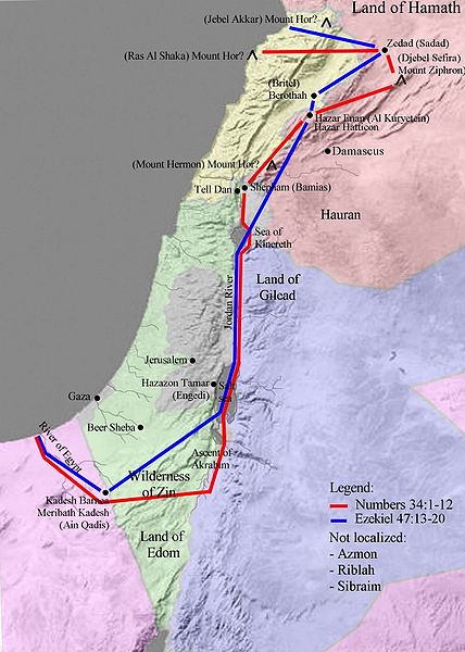 The start and end points: the southern edge of the Salt Sea and the Brook of Egypt are well known. This map shows the boundaries:
One of the many problems created by those wanting to change the crossing point of the Red Sea is the requirement to alter the locations of many sites. While it is true that many cities are hard to identify, the alterations proposed are more to fit the desired outcome than to fit the facts.
The kingdom of Edom is one of these problem areas. To fit the model you propose, the kingdom of Edom must be limited to only east of the Arabah. Yet there are many references to Edom's territory going to the Negev on the west and sometimes overlapping the Negev. I would suggest looking at Did Edom's Original Territories Extend West of Wadi Arabah? for extensive details.
When you make arguments based on assertions that significantly differ from what has generally been accepted, it does not prove your point. It only means you changed the data to match your beliefs, it doesn't prove your beliefs.
